Insert. Delete. Insert. Delete. I was in charge of planning this road trip and I kept taking off Mt. Sneffels from the spreadsheet. I read “fatal fall,” “it’s a climb not a hike,” “demoralizing but doable,” “if you lose your footing then you have the potential to fall off a nasty ledge,” and others that read “easy Class 3,” “in-freaking-credible,” etc. So were we to do it? My friend, Weisen and I wanted to do another 14er, but I was deciding between Sneffels or the easier Handies Peak. I figured, life’s a climb and if you don’t have challenges and stretch your limits, what would really be memorable? Bring it on.
Itinerary for Colorado road trip!
After 15 hours of driving (1 camping night at Sacramento Pass) we arrived in Utah.
Sunday: Moab National Park. Dead Horse Rim Loop Trail. 5.74 miles. Definitely a great intro hike to Utah and nice to stretch the legs after over 5 hours of driving here.

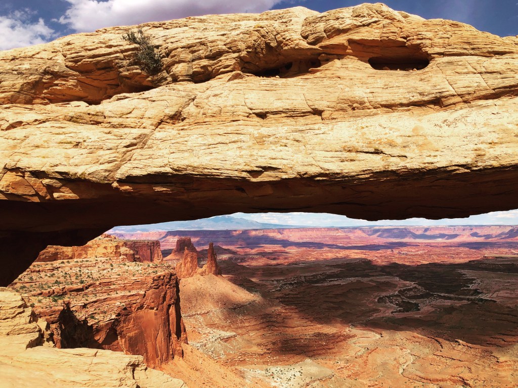
Also did Mesa Arch Trail which was only a mile roundtrip. Really worth seeing!
Monday: Canyonlands National Park. Delicate Arch Trail. 3.14 miles. Our goal was to make it there for sunrise so we woke up at 4:30 but at 5 am in the pitched black we got stuck on the road. We’re talking, the car is literally about to flip over, kind of stuck. Heart pumping, “OMG” thinking, can we get off this road questioning. We made it, but yikes, please never again. Basically an ATV wouldn’t have gotten past the road in which we were stuck and we had to do some maneuvering to get out. Anyway, pro tip for the Delicate Arch Trail – get there early!! This is a super popular hike! We started at 5:53 am and there were already people on the trail. I read in a magazine that the Delicate Arch is “immortalized on Utah’s license plate….might be the most famous image.” And yes, I have a National Parks magazine 🤓

Arches National Park. Devils Garden Loop Trail. 7.9 mile hike and 977 ft of elevation gain. But 99° so it was hoooot. I would not recommend exploring Utah National Parks in July. Thankfully this trip was the end of June. But a few weeks later would be, well, don’t do it. This is a gorgeous hike – you see seven arches. If you come back to the start via the Primitive Trail, which is what we did, expect to hike in a lot of sand. And don’t be shy on bringing water – H20 will be your friend. Arches, like many national parks, is one which has a scenic drive – this one is 18 miles long. That day we later drove 3 hours to Telluride, Colorado.

Tuesday: Telluride! Can’t express how amazing this place is. Cute town, shops, etc. and the hiking is breathtaking. Take me back! We first did Hope Lake Trail. 5 miles. 1,355 ft elevation gain. Perfect hike to adjust to the altitude. Later that day we did Bridal Veil Falls which was gorgeous too (more people / more known than Hope Lake trail). 3.74 miles (depending on how far you go) and for us just over 1k of elevation gain.

Wednesday: Got to see my best friend, Katie! She lives in Denver and when I was talking to her on a call a couple weeks prior to the trip, I had told her I was planning a road trip to Telluride, and she was like, “wait, what?! I am too!” Small world, considering Telluride is a 7 hour drive from Denver! It was so incredibly great to see her and her fam! We went on a short hike and caught up on life 😀

Ice Lakes Trail. One of my favorite (if not favorite) hikes on this trip. You feel like you’re in Switzerland, but you’re in Colorado. It reminded me so much of trekking in Europe. First went to Ice Lake, then Fuller Lake (no one really goes there and it’s worth the extra trek), then to Island Lake (the color is unbelievable). 10 miles total. 3,188 ft of elevation gain. I would do this again if I went back!

Thursday: Dragon’s Back via Horsethief Trail. 19.3 mile hike. 7,339 ft elevation gain. This took a lot of triangulating. Ask for for my Strava route and I’ll give it to ya. Because there was no trail on AllTrails for this. So it was a look at a bunch of blogs, plus hiking routes on various sites plus Google Maps and piece it together for what we wanted to accomplish. And I get why. Of the close to 9 hours of hiking we did on the trail we did not run into a single soul. 19.3 miles. 7,339 ft of elevation gain (according to Garmin). I brought 3.5 liters of water and pretty much drank all of it. We were almost to the ridge and were seeing dark clouds, then all of a sudden, thunder. “We are allllmost there,” I thought to myself. While it was a beautiful hike, we both wanted to see what we came for but knew we had to call it soon and especially turn back if there was lightning. “Just get to the ridge and if Dragon’s Back isn’t there, we’ll still turn back.” Then more lightning. But we made it. And saw it. And then it started to rain. Bring out the rain jackets! And we turned to go back. And then it started to hail. And then we started to sorta jog. And then my fingers started going numb. Later it cleared up and then it rained again! We looked far ahead and Weisen said, “what crazy people would go up that trail over there.” I responded, “I’m pretty sure that’s our trail.” Shocked look. Up and up we climbed, and hail again right in our face, to the point where you’re thinking “I don’t mind the hail, but can this switchback actually switch so the hail’s hitting my back and not my eyes.” But we finished! And, let’s be honest – we decided to do take out and had tacos. OMG yum.

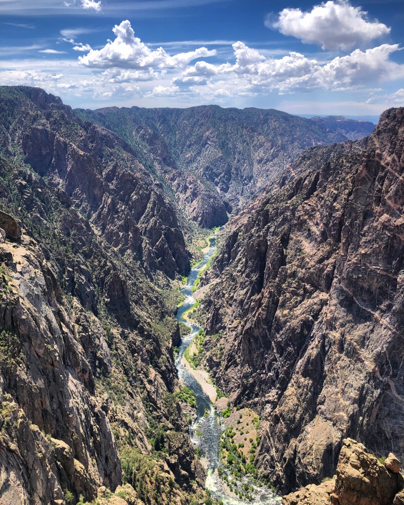
Friday: Black Canyon of the Gunnison National Park. Added this in as a rest day – we did a little over 4 miles (in two hikes) to check out the sites. Specifically: Rim Rock Nature Trail to Uplands Trail and Warner Point Nature Trail.
Saturday: Summited Mt Sneffels! Mt Sneffels is a 14er having an altitude of 14,150 ft. It is for sure a scramble. And it’s the most technical hike I’ve done: a Class 3. You definitely don’t need any rope (that’s Class 5) and it’s not super difficult, it’s just rocky! So you may slip here and there. We dislodged some rocks and you have to be aware of any rocks being dislodged in front of you (aka maintain your distance from other hikers). 50% of the hikers were wearing helmets. Probably smart in case a rock comes your way. I still need to buy one. The hardest part was a rock climbing move at the top. Look left and it’s a fatal drop. To get your feet up is a bit tricky, but once your hands are in the hold totally doable! But some hikers we were near said they were going to stop there and not do it. I get it, it’s a bit sketch to say the least. So that was the turning point for them. But we were here to summit. We got over the move, then hiked more to the top and it was incredibly awesome. There’s nothing like summiting a mountain. Now time to eat a pint of Ben & Jerry’s.

Sunday: Canyonlands National Park. Left Telluride and drove over 3 hours to get here (we stopped here for the Delicate Arch Trail on our way to Colorado). Alcove Spring Trail: 0.68 miles (was supposed to False Kiva but we went down the trailhead on the opposite side of the road). Aztec Butte Trail: 1.70 miles. And Grand View Point Trail: 1.9 miles.

Monday: 14 hour car ride back to SF!

Hi Nicole, sounds like it was a great trip! As we’re in Moab, we’ll follow some the easier hikes you did!